
Royal Canal; click map to enlarge
The Greenway (see Waterways Ireland Royal Canal Greenway ) between Maynooth in County Kildare and the Shannon in County Longford has been completed and was officially opened on the 24th March 2021. The full Greenway, when completed will offer a first-class multi-purpose off-road walking and cycling link running from the river Liffey in Dublin, through Counties Dublin, Kildare, Meath, Westmeath and Longford to Cloondara on the River Shannon.
Work is in the planning stage for the unfinished sections in the Dublin and Fingal areas and are in an advanced stage for upgrading the section between Confey and Maynooth.
Two spur lines, one from Mullingar to Loch Owel, and the other running from south of Killashee to the town of Longford, are also part of the completed Royal Canal Greenway. For Westmeath see Interactive Map.
And for Royal Canal amenities and activities see; Walking/Cycling, Boating, Fishing, Distance Tables and instructions for the use of ‘Royal Canal Smart Tags’.
Royal Canal Greenway voted best Greenway in Europe November 2023

The Royal Canal Greenway, Ireland’s longest greenway, has been awarded first place in the ‘Excellence Award’ category at the 11th European Greenways Awards.
The Awards, which took place on the 22nd November in Rome, saw the Royal Canal Greenway compete against routes such as Greenway of the Trabocchi Coast, Italy and The European Bridge and a cross-border Polish-German greenway, to be named as the leading greenway in Europe. See Link; https://ittn.ie/irish-news/royal-canal-greenway-voted-best-in-europe/
Completed sections of the Royal Greenway

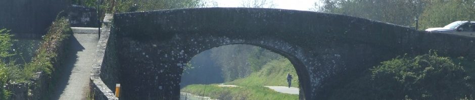
Royal Canal Way Castleknock
- Dublin Phase I: Guild St. to Upper Sheriff St. 0.5 Km
- Fingal: Ashtown, 10th lock to 12th lock at Castleknock; 2.5 km.
- Kildare to Longford: Maynooth Harbour to Richmond harbour on the River Shannon; 120 km.
- Longford: Longford Town via Killashee to Richmond Harbour, Clondra; 16.5 km
Work in progress
Dublin ? Fingal:
- Upper sheriff St. to North Strand.
- North Strand to Phibsborough;
- Broom Bridge to Ashtown; 2.25 Km. Upgrade in the planning stage,
- Deep Sinking, Blanchardstown (4 km); Fingal Council have appointed design engineers to examine the problem of upgrading the deep sinking.
Dublin to Galway East-West Link & EuroVelo Rout 2:
Ninety kilometres of the Royal Canal Way, running from Dublin city through Fingal, Kildare, Meath and Westmeath to Mullingar will form part of the proposed Dublin to Galway East-West Link.

Mullingar to Athlone: Just west of Mullingar the Royal Canal Way joins the East-West Link. This 40 Km walking and cycling route running along a disused rail line to Athlone, where it was planned to cross the Shannon into Counties Roscommon and Galway.
Athlone to Galway: This section, through Counties Roscommon and Galway was planned to be completed in 2019 and would have provided an off-road walking / cycling route from Athlone to Galway city (140 km). However, due to unresolved concerns by landowners along the proposed route this project was shelved in October 2015. See; Galway Independent (30 Oct. 2015).
EuroVelo Route 2:

Click picture for details
The planed Dublin to Galway east West Link also forms part of a Pan-European walking and cycling route, the EuroVelo 2 Capitals Route linking Galway to Moscow. However, at this stage it looks like it will run from Athlone to Dublin. Then having crossed the Irish Sea to North Wales it will wind its way south to Bristol. From Bristol the route will run via London to Harwich from where it will cross the North Sea to Holland. In Europe, the EuroVelo will run from The Hague through Holland Germany, Poland, Belarus and Russia to Moscow.
Euro Velo Rout 2 is one of fifteen walking and cycling routes that span Europe, two of which run through Ireland. The other, the Wild Atlantic Way forms part of EuroVelo Route 1 which runs along the Atlantic Coast from Norway through Ireland to Portugal.

